The dynamic partnership between construction surveyors and subsurface utility locators forms a crucial foundation in modern construction projects. Construction surveyors specialise in precise spatial measurements and mapping of above-ground structures, while subsurface utility locators focus on identifying and documenting underground infrastructure networks.
This essential collaboration delivers comprehensive spatial intelligence that spans both visible and hidden infrastructure elements. The partnership proves invaluable across diverse sectors:
- Commercial Development – ensuring safe, efficient construction of office buildings and retail spaces
- Residential Projects – supporting housing developments and apartment complexes
- Public Infrastructure – facilitating roads, bridges, and government facilities
- Telecommunications – enabling network expansion and maintenance
- Educational Facilities – supporting campus development and renovations
- Industrial Sites – assisting factory construction and warehouse developments
The integration of above-ground surveying expertise with underground utility locating creates a robust framework for risk management and project success. This combined approach helps prevent costly delays, reduces safety hazards, and ensures regulatory compliance throughout the construction lifecycle.
Role of Construction Surveyors in Construction Projects
Construction surveyors are vital professionals who offer comprehensive surveying services for property development, construction, and infrastructure projects. Their expertise covers various critical tasks that lay the groundwork for successful construction ventures.
Key Responsibilities:
- Conducting thorough site investigations and topographic surveys
- Performing boundary surveys and determining property lines
- Creating detailed site plans and elevation drawings
- Implementing precise construction staking
- Documenting as-built conditions after construction
The due diligence process requires surveyors to assess existing site conditions, identify potential challenges, and create accurate documentation for project planning. Through platting services, these professionals establish proper lot divisions and ensure compliance with local zoning requirements.
Construction staking is a crucial phase where surveyors convert design plans into physical markers on the construction site. This process guides contractors in accurately placing buildings, utilities, and infrastructure components.
Early Issue Detection:
Professional surveyors are skilled at spotting potential engineering challenges during the early stages of a project:
- Drainage problems
- Soil stability concerns
- Site access limitations
- Utility conflicts
- Boundary disputes
This proactive approach to problem identification helps prevent expensive delays and changes during construction. By upholding strict accuracy standards and using advanced surveying equipment, construction surveyors provide the spatial data needed for informed decision-making throughout the project lifecycle.
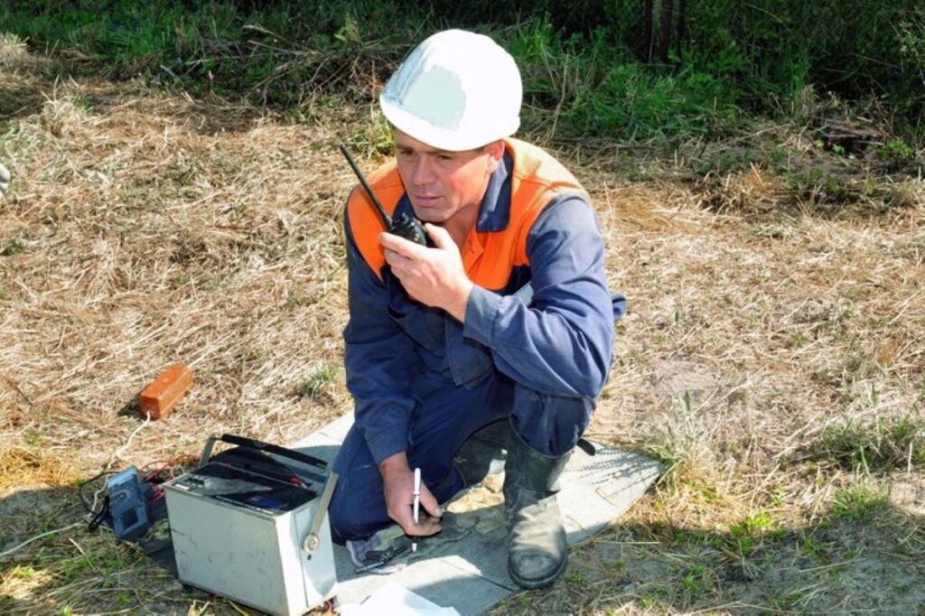
Importance of Subsurface Utility Locating
Subsurface utility locating is a crucial safety measure in modern construction projects. This specialised service identifies and maps underground infrastructure such as water pipes, electrical cables, gas lines, and telecommunications networks that are buried beneath the surface.
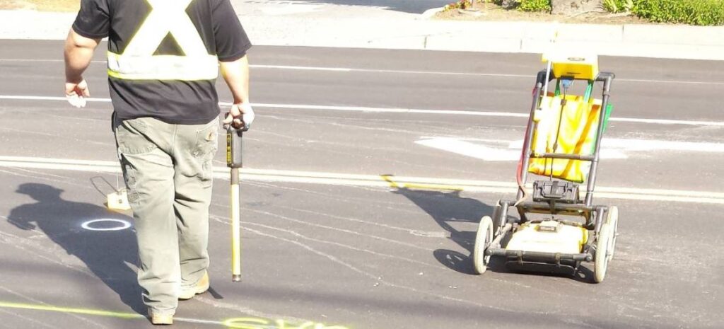
Advanced Technologies for Accurate Detection
Advanced technologies have transformed the accuracy and reliability of detecting underground utilities:
- Ground Penetrating Radar (GPR) – Provides detailed imaging of subsurface structures without disturbing the ground
- 3D Laser Scanning – Creates precise three-dimensional models of underground utility networks
- Photogrammetry – Captures detailed visual data to supplement utility mapping
- LiDAR Point Cloud Capture – Generates high-resolution spatial data for comprehensive site analysis
Benefits of Technological Capabilities
These technological capabilities deliver substantial benefits to construction projects:
- Precise mapping of utility depths and locations
- Early identification of potential conflicts between planned construction and existing utilities
- Creation of detailed digital records for future reference
Impact on Project Success
The implementation of professional utility locating services directly impacts project success through:
- Reduced risk of utility strikes during excavation
- Prevention of costly service interruptions
- Minimized project delays from unexpected utility discoveries
- Enhanced worker safety through detailed knowledge of underground hazards
- Protection of critical infrastructure from accidental damage
The integration of utility locating services is essential for maintaining project timelines and protecting valuable underground assets. This systematic approach to managing underground infrastructure supports informed decision-making throughout the construction process.
Advanced Technologies Enhancing Utility Locating and Surveying
The integration of cutting-edge technologies has revolutionised the accuracy and efficiency of utility locating and surveying practices. These advancements enable professionals to create detailed underground infrastructure maps with unprecedented precision.
Ground Penetrating Radar (GPR) Systems
- High-frequency electromagnetic waves penetrate ground surfaces
- Real-time imaging of subsurface structures up to 30 metres deep
- Non-destructive identification of metallic and non-metallic utilities
- Precise depth and location measurements within centimetres
3D Laser Scanning Technology
- Captures millions of data points per second
- Creates detailed point clouds of above-ground infrastructure
- Generates accurate 3D models for complex site planning
- Enables clash detection between proposed designs and existing utilities
LiDAR Mapping Solutions
- Combines aerial and terrestrial scanning capabilities
- Produces high-resolution topographic surveys
- Maps large areas efficiently with minimal site disruption
- Integrates seamlessly with GIS and CAD systems
Digital Utility Mapping Benefits
- Centralised database of utility locations and specifications
- Real-time updates and modifications to existing records
- Enhanced collaboration between project stakeholders
- Reduced risk of utility strikes during construction
- Improved project planning and cost estimation accuracy
These technological advancements have transformed traditional surveying methods into sophisticated digital workflows. The combination of GPR, 3D scanning, and LiDAR creates comprehensive utility maps that serve as valuable assets throughout the construction lifecycle. Digital mapping platforms enable seamless data sharing and updates, ensuring all stakeholders work from the most current information available.
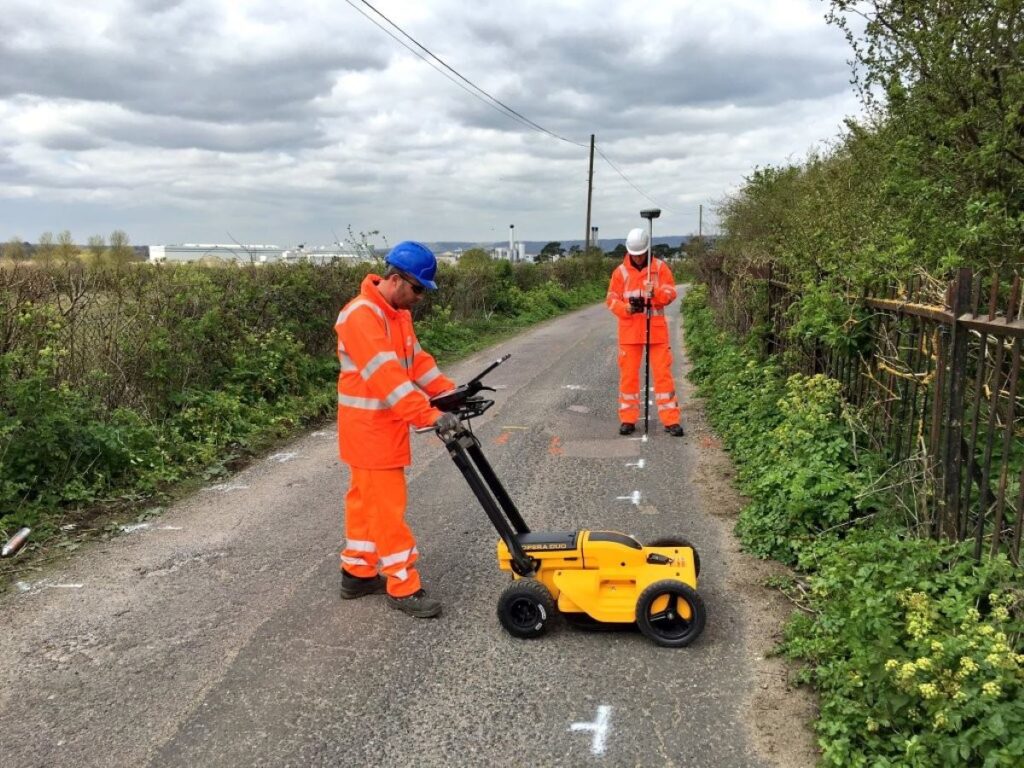
The Critical Partnership Between Construction Surveyors and Utility Locators
The integration of above-ground and below-ground spatial data creates a comprehensive site understanding that revolutionises project planning. Construction surveyors and utility locators work together to produce detailed site documentation, combining surface topography with underground infrastructure mapping. This unified approach enables:
- Enhanced Safety Protocols
- Precise identification of high-risk areas
- Development of targeted excavation strategies
- Creation of detailed hazard management plans
- Streamlined Regulatory Compliance
- Documentation meeting local council requirements
- Adherence to Australian Standards AS5488
- Compliance with Work Health and Safety regulations
The partnership delivers significant cost benefits through risk mitigation and efficiency gains. A recent infrastructure project in NSW demonstrated a 30% reduction in project timeline when both specialists collaborated from the initial planning phase. The early detection of utility conflicts prevented costly redirections and minimised construction delays.
This collaborative approach proves particularly valuable in urban development projects where complex utility networks exist. The combined expertise allows for:
- Real-time problem-solving during construction
- Accurate budget forecasting
- Reduced likelihood of service interruptions
- Minimised impact on surrounding infrastructure
The synergy between these specialists transforms potentially hazardous excavation work into precisely planned operations, establishing new standards for construction project management.
Comprehensive Services Offered by Utility Locating Companies
Modern utility locating companies deliver an extensive range of specialised services beyond basic underground detection. These comprehensive solutions include:
1. Preventive Maintenance Programs
- Regular infrastructure inspection schedules
- Early detection of potential issues
- Asset condition monitoring
- Documentation and reporting systems
2. Emergency Response Services
- 24/7 incident investigation capabilities
- Damage assessment protocols
- Rapid response teams for critical situations
3. Advanced Pipeline Solutions
- High-precision pipeline mapping
- Depth and alignment verification
- Corrosion detection
- Material composition analysis
The integration with renewable energy projects demonstrates the evolving scope of utility locating services. Companies now provide specialised support for:
- Battery storage facility installations
- Solar farm developments
- Wind energy infrastructure
- Electric vehicle charging networks
These services prove essential across multiple sectors:
Telecommunications
- Network infrastructure planning
- Cable pathway verification
- Signal interference prevention
Education Infrastructure
- Campus utility mapping
- Safety compliance assessments
- Expansion planning support
Power Generation
- Grid connection surveys
- Transmission line routing
- Substation development planning
The breadth of these services reflects the growing complexity of modern infrastructure projects and the critical role utility locating companies play in their successful delivery.
Case Studies Highlighting Effective Collaboration
The successful partnership between construction surveyors and utility locators becomes evident through real-world project implementations across Australia. Wumara Group’s extensive portfolio in NSW and QLD markets demonstrates the practical impact of this collaboration.
Telecommunications Infrastructure Projects
- CI International’s network expansion required precise utility mapping and surveying across multiple urban sites
- Complex NBN rollout projects benefited from integrated above-ground surveying and underground utility detection
- Telstra’s infrastructure upgrades achieved significant time savings through coordinated surveying and utility location services
School Infrastructure NSW (SINSW) Development
- Comprehensive site investigations combining surveying and utility mapping for 12 educational facilities
- Identification of previously undocumented underground services prevented potential construction delays
- Digital documentation of existing infrastructure supported efficient planning of new educational facilities
Notable Project Outcomes
- 35% reduction in project timeline through simultaneous surveying and utility location
- Zero utility strikes recorded across mapped areas
- Enhanced accuracy in construction planning through detailed 3D utility mapping
- Successful integration of new infrastructure with existing underground services
These case studies highlight the tangible benefits of coordinated surveying and utility location services. The combination of technical expertise and advanced technology has proven essential for project success across various sectors.
Client Benefits from the Construction Surveyor–Utility Locator Partnership
The collaboration between construction surveyors and utility locators provides significant advantages for clients in various industries. Client feedback consistently highlights three main benefits:
1. Superior Service Quality
- Rapid response times to project requests
- Professional communication throughout project lifecycle
- Detailed documentation and reporting
- Experienced teams with specialised expertise
- Proactive problem-solving approach
2. Cost-Effective Solutions
- Flexible pricing structures adapted to project scope
- Scalable service packages
- Transparent cost breakdowns
- Negotiable rates for long-term partnerships
- Bundled service discounts
3. Risk Mitigation and Value Creation
- Early identification of potential challenges
- Reduced likelihood of utility strikes
- Minimised project delays
- Enhanced safety compliance
- Accurate data for future reference
The partnership’s integrated approach delivers measurable results through precise utility mapping and comprehensive surveying data. Clients benefit from streamlined project management, with a single point of contact coordinating both above-ground and underground services. This unified service model has proven particularly valuable for complex infrastructure projects requiring multiple survey and utility location phases.
Recent client feedback demonstrates consistent satisfaction with service delivery standards and project outcomes. The combination of technical excellence and customer-focused operations creates lasting partnerships that extend beyond individual projects, supporting clients’ long-term development goals.
Conclusion
The partnership between construction surveyors and subsurface utility locators is crucial for successful infrastructure development. This collaboration combines above-ground precision with underground awareness, creating a comprehensive approach to project planning and execution.
By integrating advanced technologies, professional expertise, and coordinated workflows, we establish a strong foundation for:
- Risk mitigation in construction projects
- Enhanced project timeline management
- Cost-effective infrastructure development
- Regulatory compliance assurance
- Long-term asset protection
This unified approach is essential for the future of infrastructure development. As urban areas become more complex, the relationship between construction surveyors and utility locators becomes critical for project success. Their combined knowledge, supported by innovative technology and systematic methods, protects infrastructure investments and promotes sustainable development practices.
This important partnership continues to grow and improve, setting new standards for construction excellence and resilience in an ever-changing built environment.
Related : Engineering Surveyors: Supporting Infrastructure Projects with Precision